Syrian Space: Images, Activism, and Cartographic Rendering
Khaled Akil & Alex Granato
To cite this contribution:
Akil, Khaled, and Alex Granato. ‘Syrian Space: Images, Activism, and Cartographic Rendering.’ In response to Sohin Hwang and Pablo de Roulet, ‘Bibliography(chorème)=’ OAR Issue 1 (2017). OAR: The Oxford Artistic and Practice Based Research Platform Issue 1 (2017), http://www.oarplatform.com/syrian-space-images-activism-cartographic-rendering/.
Khaled Akil is a Syrian photographer and mixed media artist. Khaled’s first exhibition was held in 2009, when he was completing his bachelor’s degree in law. His experience in law, politics and human rights has played a major role in his artistic development and projections. Most of his work deals with topics related to the social, political, and religious discrepancies he witnessed around the region.
Alex Granato graduated from Oxford in 2013 with an MSt in History of Art and Visual Culture. Since then, he has completed an MSc degree in Middle East politics at SOAS, where he spent a year studying Arabic. His thesis explored the work of Syrian nonviolent activists, and their creation of alternative spaces and revolutionary communities. He has also spent a summer studying French at the Sorbonne in Paris, and is currently working as a trainee at the European Parliament in Brussels.
The first five images in this response are by Khaled Akil, from the series Pokémon Go in Syria – Part 1 (2016). The last four images are by Khaled Akil, from the series This is Aleppo.
From Alex
Studying the Middle East in London whilst never having visited the spaces and communities that were the object of my studies is an unusual experience. Maps and images became my experience of the region. When I prepared my thesis, I began to think more about how maps can create spaces and change communities. As my research started to look at alternative cartographies and uploading spaces, I thought about this alongside the Pokémon Go app popular at the time which used cameras and recorded space overlaid with digital moving creatures. Pokémon Go, a phone app and game, links with smartphone cameras and mapping technology to allow users to ‘hunt’ and ‘catch’ 3-D Pokémon characters. I wrote an article about it for my blog and sent it to Khaled. Khaled’s subsequent response inspired this collaboration. Sharing ideas and images led to this article, put together from weeks of online correspondence.
With the aim of preserving and maintaining ‘social relationships by providing a repository for the materials and personal histories of those living in…disappearing close-knit communities,’1 the Ajam Media Collective has established Mehelle – from the Arabic mahallah meaning neighborhood or quarter – a mixed-media online project that aims to record and preserve ‘the sights, sounds, and stories of endangered neighborhoods.’2 The project uses 360 degree videos, digital mapping, and photography to record the spaces once inhabited by thousands of people. Its first featured location is Sovetzki, a neighborhood within Baku, Azerbaijan that has been mostly demolished as part of many state-led urban beautification projects symptomatic of the rise of post-Soviet capitalism throughout Central Asia, the Middle East, and the Caucasus. The project is uploading an experience of space into the digital realm, before that space is stripped of the relics of its history and culture to make way for a sterile bastion of consumerism. The lived and historic spaces of communities now become internet archives, a simulation of a physical space that once was. These new landscapes are often designed with elite global tourists in mind, meeting their tastes and expectations, rather than focusing on the needs of local communities. It takes projects like Mehelle to re-invigorate local spaces, and remind future generations of the people in Sovetzki what their home was once like. Indeed, this memorialising quality is inherent to the project, and points to a ‘death’ of a landscape, along with the lives lived within it. Maps and cartography are changing dramatically as our ability to record, upload, and save millions of images and videos, panoramic, in succession, and in 360-surround continues to expand. With this come changes to the ways in which we experience and remember space, and the social relations that we create within it.
The way we encounter memories materially, through images, is no longer primarily through physical copies and printed albums. As well as digital images, archived online, we now have the ability to remember past experiences, and the experiences of those who have gone, by experiencing the past spatially, through archived virtual space. Through digital cartography, memory can be, in a sense, re-lived in a more embodied and three-dimensional way, through augmented and simulated 3-D spatial reality. The recent phenomenon of Pokémon Go perhaps appears as a trivial juncture, but it demonstrates the consequences of a new kind of digital cartography that alters the way we experience space. The player of Pokémon Go uses his or her smartphone camera like a telescope to ‘see’ Pokémon characters. Through this augmented space, the ‘map’ and its recording of space today are no longer just the zoomed out designated shapes of the earth and its political borders. Through mapping technology like Google Maps, the map is now also a record of the individual in space. The Pokémon Go app allows users to experience the same space as those around them, but with a hidden layer of individually perceived reality. Often, this added perception can appear more than bizarre for those not looking through their phones, as people immersed in the game appear entirely lost in their surroundings, completely absorbed in moving through a virtual space as they are physically guided by the lens of a smartphone.
This myopia can be extended to the experience of social space: cartographies can reveal alternate layers of reality that exist in the same space and time, but may only be visible to certain groups or ‘users.’ William ‘Holly’ Whyte has described a process of ‘triangulation,’ an ‘age-old process by which some external stimulus provides a linkage between people, prompting strangers to talk to one another as if they knew each other.’3 Such a process can alter how users interact with public space, and can even invoke a sense of shared belonging, cultivating communities and shaping social spaces.4 Yet, the potential to create these shared social spaces also relies on disengaging groups of users from other aspects of their surroundings, even distracting them from potentially more urgent realities and dangers.
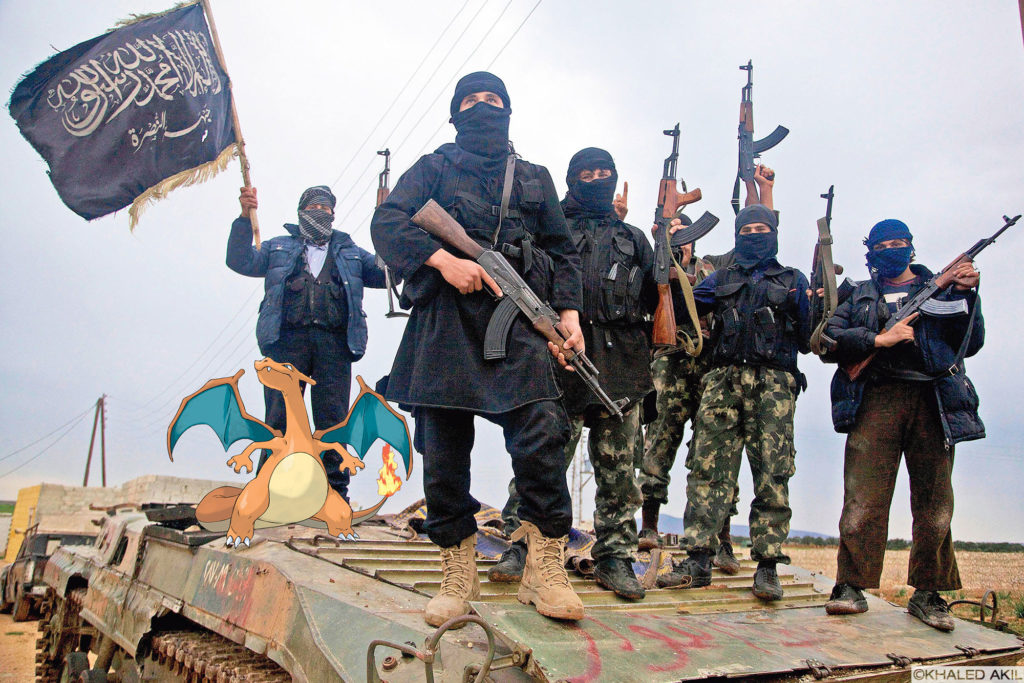
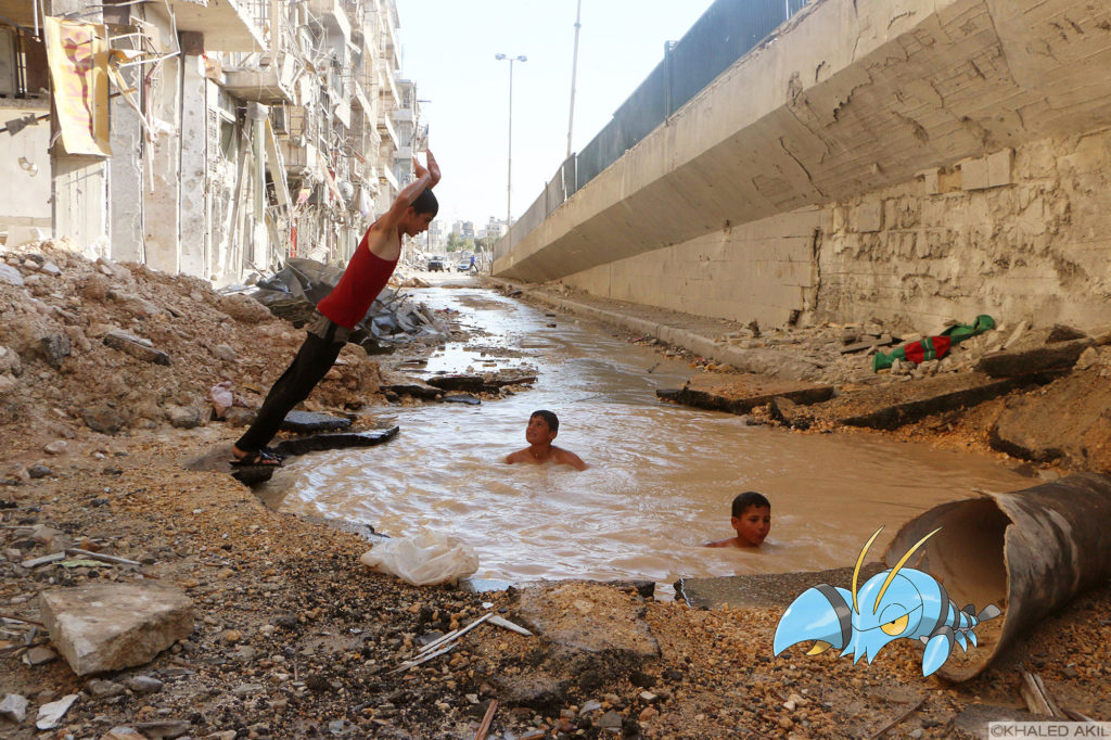
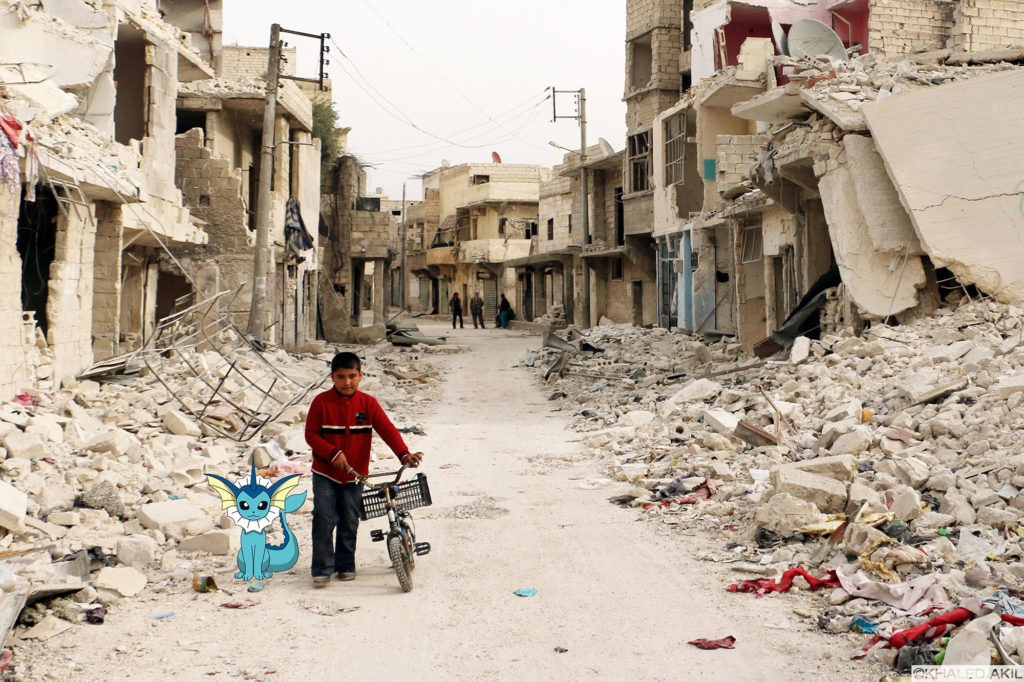
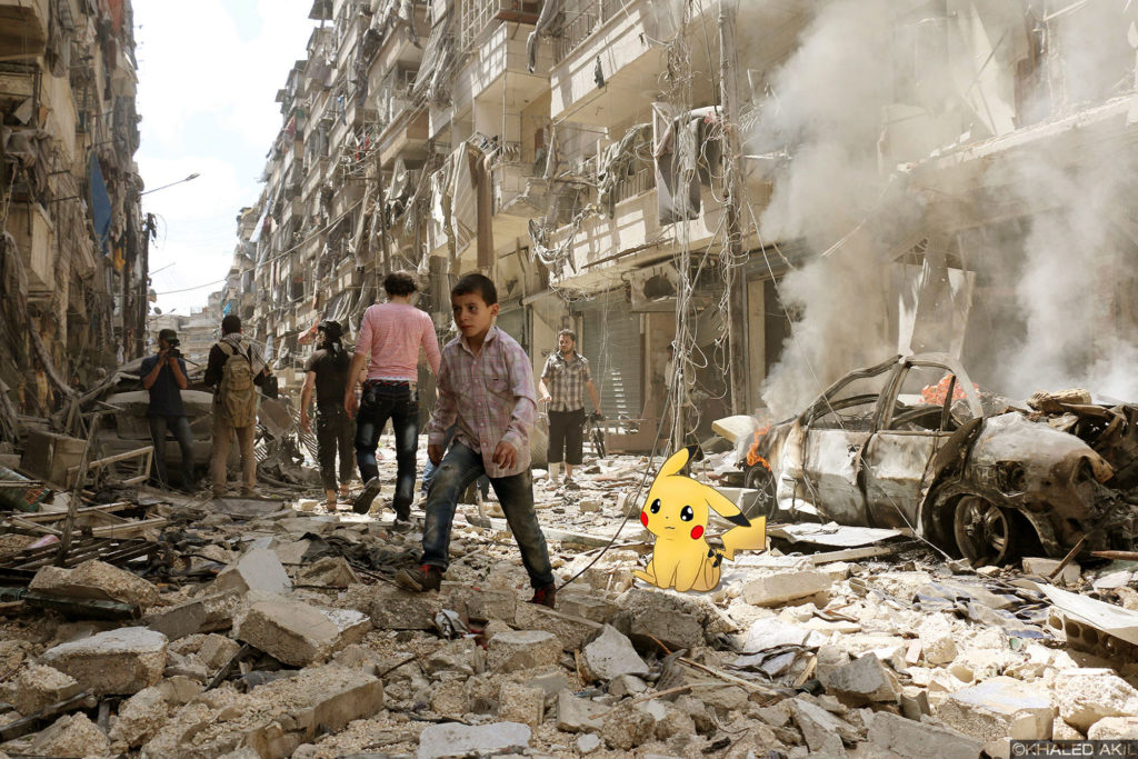
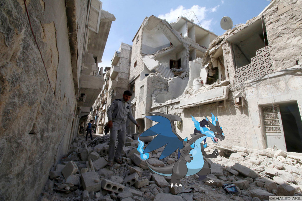
Syrian artist Khaled Akil took note of the Pokémon Go phenomenon as the conflict in Syria raged on, and the media became simultaneously saturated with images of landscapes and cities destroyed by war, interspersed with the incongruity of Pokémon’s cheerful cartoon characters taking over (much of) the world’s virtual map. Khaled responded to this visual and social contradiction, creating a series of images titled Pokémon Go in Syria – Part 1.
From Khaled
Technology today, and especially the new relationship between the Internet, social media and maps have created another dimension to this world; a parallel world where you can fly with no boundaries. The best example I can provide from my personal experience is my latest project Pokémon Go. It was a moment when reality and the virtual world hit together in one place: every news outlet was talking about this game alongside footage from Syria showing the tremendous destruction and the tragedy taking place there. I tried to portray all the factors of this war – the destruction made by all parts, with no exceptions. I focused especially on the first victims of any war, namely children, who are also the next generation that is supposed to rebuild the country. Watching reports of Syria alongside the news of this game forced me to think about what it would look like to hunt for a Pokémon character amongst the rubble in Syria. When this series went viral all around the world, it was a great opportunity to get Syria’s story heard through art. I believe that people are tired of watching news, and the role of art is essential in delivering any political or social message.
I remember when I first left my city, I followed Aleppo’s news daily, and especially the old city; we were all concerned about the situation there, and that was the point when I started using Google maps to check my city. Whilst I was scrolling up and down, I thought about visiting my house, then the places where I used to hang out with my friends. From that day, I’ve been using Google maps to visit my home city whenever I missed it. Following the news of the old city was agonising. Watching the old city being destroyed – it’s like someone erasing your memories, killing your past, and asking you to forget everything about your previous life. I think this is the unseen war crime of all wars: erasing one’s memories and replacing them with horror, destruction and despair. When you are in such a situation you unconsciously start to deny it, and there is nothing better for this denial than an old upload to Google maps. For a period of three years, Google didn’t update its maps – all maps were taken in 2009 – and seeing these pictures enabled me to virtually travel there; it was like a trance.
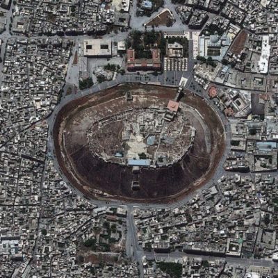
Screenshot from Google Earth of Aleppo.
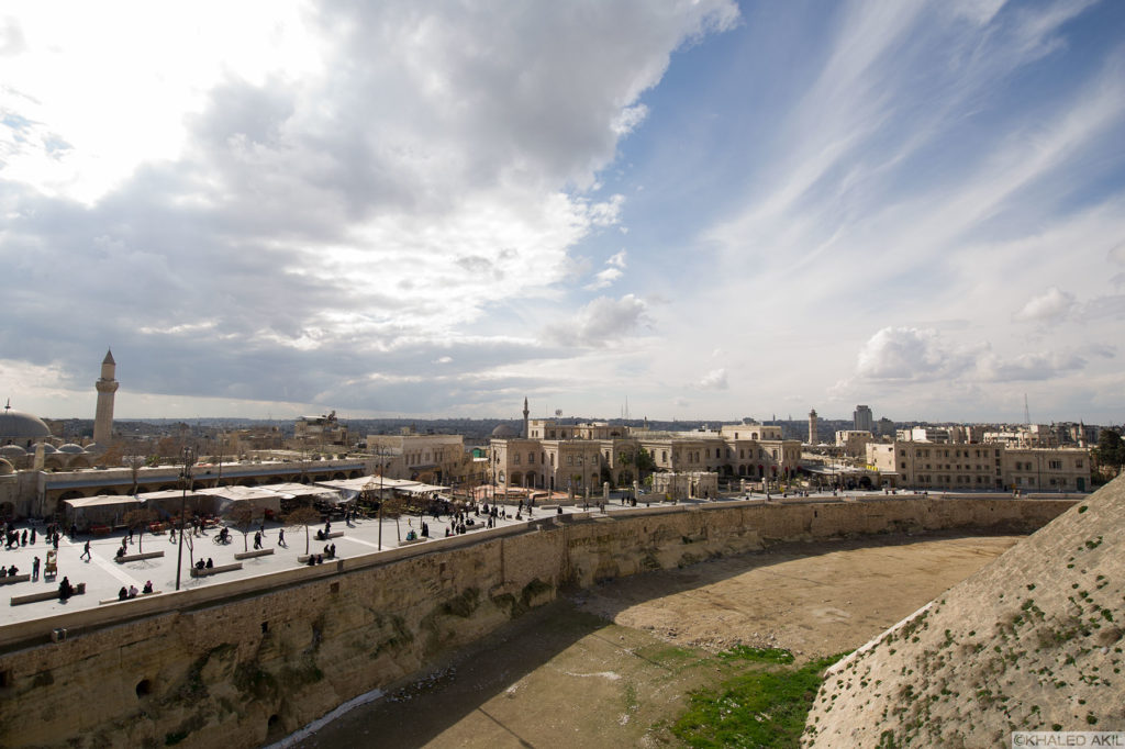
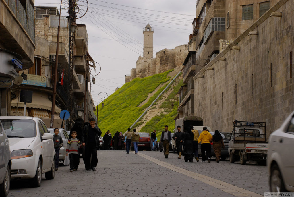
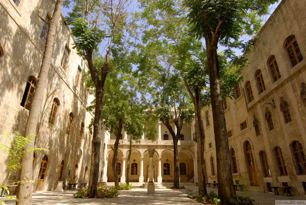
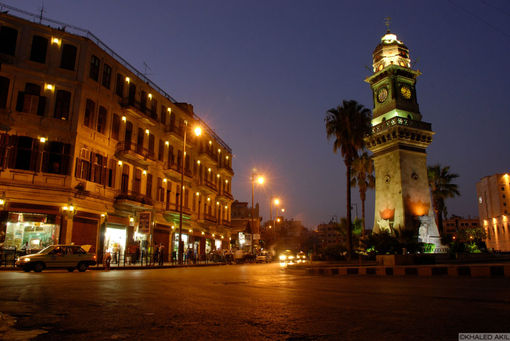
In such situations, photography and art become a way of resistance, to fight back and to keep the beautiful image of our previous life. In 2012, armed groups took over the old city of Aleppo, a UNESCO World Heritage Site, turning it into a battlefield, with catastrophic consequences. The result was tremendous destruction of all the city’s important sites, leaving this historic and beautiful city demolished. Last year, an American politician didn’t know what Aleppo was upon being asked. I decided to make a hashtag #ThisisAleppo and support it with coloured photographs from the city. These photographs aren’t only showing the old city of Aleppo, they’re also representing daily life and how people used to live. Matching these photographs with maps is what I’m planning to do: if you Google the old city now you see nothing but war photographs, what I’m working on is adding to these Google maps with old photos of the city. For me, old Aleppo is like Atlantis now: it’s not there anymore; the difference is that we know it once existed, and we can prove it with photographs.
From Alex
Whilst a narrative of war and conflict comes to dominate the images and stories surrounding Syria, for many Syrians the story goes back to a country of great beauty. The political resonance of cartography and its ability to re-define our social relations emerge in Syria in ways that re-configure the narrative of the conflict. Non-violent activists have used maps to coordinate non-violent resistance and civic life across Syria, in an attempt to resist tyranny and violence. The digital map is used to configure behaviour that not only alters how we interact in space but, indeed, how we interact with each other. Omar Al-Assil and other activists created an online map of proliferating non-violence projects across Syria; these inter-connecting zones of action allow users to click on nodes that unfurl to provide the specific details of various activities. These maps don’t merely show representations of territory, but fuse nodes of activity that proliferate rhizomatically across urban and rural space, providing connections and a means of interactive solidarity. By charting this activity, we see the creation of networks across space that has seen Syrian activists brought closer together, transcending geographical distance.
In Syria, maps are also being used as records of human rights violations, to be carefully analysed and archived for the end of the conflict, as seen in the work of the Syria Justice and Accountability Project.5 These maps become a powerful tool to be wielded in a future court of law, when Syrians and their families seek justice. Not only do these sites become markers of pain and suffering, they can function as geographical sites of hope and future transitional justice. Indeed, Alex Schank argues that this justice will serve to heal sectarian rifts worsened by political involvement during the conflict.6 These maps have also aided those fleeing the conflict. People have utilised cartographic technology to chart their harrowing journeys at sea with real-time maps uploaded to Facebook. This has seen activists on both shores engage in civil solidarity projects that alert coastguards of the Syrians’ presence, and need for rescue.
The capabilities of map-making as a form of citizen power and claim to justice is expanding. Forensic Architecture uses spatial analysis and cartography to re-create human rights violations to prepare cases for court.7 In what is called ‘data-driven, participatory fact mapping,’ forensic architects hope to upload conflicts and significant events in a visual data cluster that can be verified and engaged with to lend greater nuance to the situation for journalists and the public, but also to record crimes for use in human rights cases. The programme PATTRN, which uses digital cartography, could transform human rights work in the digital age. Space and our everyday technology – our phones, tablets and computers – can become progressive tools of accountability, strengthening our ability to record, share, and form networks with regard to our ever-changing spaces and their conditions of existence.
For many Syrians, the memories of a past without war is linked to the spaces they shared, with many now destroyed. By forming their own cartographies of community projects and resistance, activists are able to re-create and orchestrate their own spaces in response to and in spite of violence. As maps function as records of spaces used for orientation, image archives and the recording of resistance activities on the ground offer others the possibility to virtually orient themselves within an alternative political reality. Whilst in an age where digital Pokémon creatures augment reality for entertainment purposes and distract many from their geopolitical surroundings, the same layering of space via the digital medium can allow for our surroundings to be imbued with political narratives. As Pokémon Go allowed everyday locations to emerge as places of sociality and play, similar sites can be augmented to create interactive sites of resistance, community and power, resisting dominant practices that would normally see them reduced to merely names on a static map.
1. Rustin Zarkar, ‘Ajam’s Mehelle: Recording Everyday Life in Endangered Neighborhoods,’ 10 October 2016, accessed 10 April, 2017, https://ajammc.com/2016/10/10/mehelle-recording-life-endangered-neighborhoods/.
2. See: http://www.mehelle.org/, accessed 10 April, 2017.
3. William (Holly) White, ‘Eleven Principles for Creating Great Community Places,’ https://www.pps.org/reference/11steps/.
4. See ‘Go Pokémon GO!: The Social Life of Virtual Urban Spaces,’ accessed 10 April, 2017, https://www.pps.org/blog/go-pokemon-go-the-social-life-of-virtual-urban-spaces/.
5. See https://syriaaccountability.org/, accessed 10 April, 2017.
6. Alex Schank, ‘Sectarianism and Transitional Justice in Syria: Resisting International Trials,’ Georgetown Journal of Interntional Law 45 (2014): 557–87.